Kenai Peninsula Borough
144 N. Binkley Street
Soldotna, Alaska 99669
Resurrection River
Debris Maintenance Plan
(A requirement under DR-1072-AK)
Kenai Peninsula Borough
Office of Emergency Management
(907) 262-4910
www.borough.kenai.ak.us/emergency
September, 2006
Resurrection River Debris Removal Maintenance Plan
PURPOSE
The purpose of this Plan is to fulfill the tasks set forth by the Resurrection River Task Force and KPB Ordinance 2003-30, which established the SBCFSA, and to meet the requirements of DR-1072-AK. Debris removal maintenance is central to this Plan. The terms “debris removal” and “bed-load extraction” are interchangeable in the context of this Plan.
This Plan will undergo cooperative annual review, with revision as needed. Review and revision will be a collaborative effort open to all agencies associated with the Plan, for input and evaluation of cause and effect of individual agency actions upon others related to the Plan.
HISTORY
1995
In the aftermath of the 1995 fall flooding, the Kenai Peninsula Borough (KPB) initiated a 3-phase hazard mitigation planning process to assess Borough-wide risks and identify preventative measures to reduce those risks.
· Phase I
o Covered areas along the Resurrection, Kenai, and Kasilof River systems subject to repetitive flooding.
· Phase II
o Encompassed the remaining flood-prone areas of the Borough.
· Phase III
o Expanded flood mitigation planning to a Borough-wide Disaster Hazard Mitigation Plan to provide comprehensive approach to reduce loss of life, property, and community disruption when a disaster occurs.
With a patchwork of public and private land ownership within the KPB, there are many agencies and individuals with an investment in flood mitigation planning. Also, there are many layers of state, borough, city, and federal laws and regulations that govern the management of lakes, streams, rivers, and coastal areas. The complexity necessitated a broad management perspective for mitigation planning.
1996
On March 1 the KPB Mayor published the Phase I “Flood Mitigation Plan” that included a flood history and floodplain management description, a description of flood mitigation planning zones, and flood mitigation goals and approaches to accomplish them.
1997
A Japanese (Japp) Creek/Resurrection River Interagency Agreement and Task Force were formed that included the following signatories and their general responsibilities:
· ADES: (now DHS&EM)
o Grant project selection
· City of Seward:
o Japanese (Japp) Creek mitigation grant project
· Kenai Peninsula Borough:
o Resurrection River mitigation grant project
· FEMA:
o Endorsed and funded projects
· Alaska DOT/PF:
o Bridge replacement/enlargement in both projects, raise Seward Highway above flood plains, build cross drainage on Seward Highway project
· US Army Corps of Engineers:
o Reconnaissance study for levee from Seward Highway upstream to east boundary of Forest Acres Subdivision
· Alaska Railroad Corporation:
o Enlarge railroad bridges to same size as Seward Highway bridges
· Natural Resources Conservation Services:
o Built segment of Japanese (Japp) Creek levee
· Alaska Department of Fish & Game:
o Protect fish and wildlife in both project areas
· US Fish and Wildlife Service:
o Protect fish and wildlife in the US
· Alaska Dept. of Community and Regional Affairs: (now Alaska Department of Commerce, Community and Economic Development)
o Administer National Flood Insurance Program and flood plain management programs
ADES (DHS&EM) selected the grant applications of the City of Seward for Japanese (Japp) Creek and of KPB for the Resurrection River. FEMA endorsed the selections, and all signatories recognized the importance of reducing flood damage in an environmentally sound manner and the benefits of coordinating the mitigation projects. All signatories agreed:
· To perform their responsibilities associated with these projects;
· To coordinate technical aspects of all separate projects to minimize floods and reduce damage due to flooding;
· To select a flow model to be used by all agencies when assessing alternative mitigation measures;
· To implement only alternative measures that contribute to achieving the goals of minimizing flooding and related damage;
· To share data and information with all other signatories;
· To coordinate administrative, logistical and financial matters of joint concern;
· To keep congressional and legislative staffs informed of all aspects of the program and seek further financial assistance as needed;
· To coordinate public relations; and
· The City of Seward and KPB agreed to regulate and manage development in these floodplains in a manner consistent with agreed objectives to reduce flooding and damage.
Five groups were established under this Task Force agreement:
· Multi-agency Coordination Group (MAC):
o Ultimate responsibility for the Task Force
o Provide direction and guidance to the Task Force Council
o Initiate formal coordination with congressional and legislative members
o Relay information to the Governor’s Disaster Management Policy Cabinet and respective agencies
· Task Force Council:
o Direct activities of the Task Force under general guidance from the MAC Group
· Congressional and Legislative Community Relations Staff:
o Initiate appropriate contact through the MAC Group
o Responsible for Task Force community relations and public meetings
· Project Managers:
o Provide technical services to the Task Force
· Operations Section:
o Determine and implement solutions
o Select flow model to use in evaluating alternative measures
o Select measures for implementation
o Turn projects over to agency responsible for actual work
1998
The DOT/PF Central Region released the “Preliminary Design for the Seward Highway Crossings of the Resurrection River.” The purpose of the document was to evaluate the hydraulic conditions on the Seward Highway crossing of Resurrection River and make design recommendations for reducing the risk of major flooding from the river. It recognized the importance of a major coordination effort required between various jurisdictions in order to accomplish this task. It identified locations, history, economy, transportation climate, hydrology, the 1995 flood event, the Task Force, preliminary design recommendations and culture of the project area, and the importance of coordination.
![]() The Resurrection River/Japanese (Japp) Creek Flood Mitigation Task Force completed its initial
work on May 8, 1998 with the release of its report “Task Force Report, Resurrection
River/Japanese Creek Flood Hazard Mitigation Project.” The report identified five projects
including:
The Resurrection River/Japanese (Japp) Creek Flood Mitigation Task Force completed its initial
work on May 8, 1998 with the release of its report “Task Force Report, Resurrection
River/Japanese Creek Flood Hazard Mitigation Project.” The report identified five projects
including:
· Construction of levees (City of Seward & National Resources Conservation Service)
· Increase bridge spans on railroad trestles (ARR)
· Raise height of Seward Highway (DOT)
· Debris and sediment removal (KPB)
· Provide comprehensive flood mitigation plan to protect Seward against flood risks associated with the Resurrection River and Japanese Creek (KPB & Interagency Task Force)
It is important to note that all five projects identified in this Plan are required for the plan to be effective. Without each component, flood risk remains high.
As of February 2003, bed-load extraction at the mouth of the Resurrection River and construction of the Japanese Creek levee extension have been completed by the City of Seward, with support from other agencies.
1999
The KPB completed mitigation tasks under its purview and transferred remaining FEMA/OEM grant funds to the City of Seward to complete projects within the City. The City of Seward completed mitigation tasks under its purview. The original grant criteria included the following conditions to be completed before final disbursement of funds:
· The KPB and City of Seward were required to adopt ordinances
![]() committing both
jurisdictions to funding and performing ongoing maintenance to the area to ensure
that the Resurrection River’s hydraulic capacity is maintained to post-project
configuration. Funding of this project precludes any future FEMA funding for
sediment and debris removal in the project area.
committing both
jurisdictions to funding and performing ongoing maintenance to the area to ensure
that the Resurrection River’s hydraulic capacity is maintained to post-project
configuration. Funding of this project precludes any future FEMA funding for
sediment and debris removal in the project area.
![]()
· The Alaska Railroad was required to improve and expand bridges on a specific schedule as planned by DOT/PF.
Implementation of the grant by the Sub grantee was required to be in accordance with these conditions:
· The KPB and Seward were required to establish a program to annually assess hydraulic capacity and cross section of the project and implement debris and sediment removal operations, when necessary.
· Coordinate with the US Army Corps of Engineers.
· Complete and submit a Coastal Zone Management Act Review questionnaire.
· Apply for and obtain required Title 16 review and permit from Alaska Department of Fish & Game and to comply with all conditions imposed as a result of the review.
· Apply for and obtain a Floodplain Permit from the KPB and comply with conditions of the permit to the satisfaction of the KPB.
· The National Marine Fisheries Service and Alaska Fish & Game restrict in-water work
to between May 15th and July 15th.
![]()
· Consult with US Fish & Wildlife Service regarding impacts to roosting eagles, and comply with seasonal, distance and other restrictions imposed.
· Stream bank/riparian vegetation prohibited from being disturbed unless first authorized by National Marine Fisheries Service, US Fish and Wildlife Service, and Alaska Fish & Game.
2001
The KPB and the USGS entered into a joint funding agreement to install and maintain a Stream-gaging Network to monitor water levels, surges and flooding across the Kenai Peninsula Borough. The system has been online since then.
2003
The KPB Clerk certified a petition, subsequently passed by voters, to establish the Seward-Bear Creek Flood Service Area to provide mitigation, response, and recovery services for the area that includes the Resurrection River.
The KPB Assembly adopted Ordinance 2003-30 establishing the flood service area with a seven-member board made up of four seats from within the City of Seward and three seats outside the City. The seats were initially appointed, and in October 2004 all seats were on the regular election ballot.
The board is responsible for developing, implementing, and updating a development plan for providing flood protection services and for determining the level of such service to be provided. Kenai Peninsula Borough Code Chapter 16.50 “Seward-Bear Creek Flood Service Area” defines boundaries, mill levy ability, and general functions of the Board.
2004
The KPB completed and adopted a Borough-wide All Hazard Mitigation Plan. All cities completed Annexes to the Plan and were adopted locally. These all hazard plans identify flood hazards, address vulnerability assessments and impacts, describe the National Flood Insurance Program, and describe mitigation measures.
These can be viewed in their entirety on the KPB Office of Emergency Management (OEM)
website at www.borough.kenai.ak.us/emergency.
![]()
2005
In July, the Seward-Bear Creek Flood Service Area Board (SBCFSA) completed drafting the
“SBCFSA Flood Hazard Mitigation Plan”
![]() and forwarded it to the KPB for review. The plan
identifies areas of concern and short-term, mid-term and long-term methods to address the
concerns. It also identified issues to be resolved to allow mitigation efforts to continue effectively,
including:
and forwarded it to the KPB for review. The plan
identifies areas of concern and short-term, mid-term and long-term methods to address the
concerns. It also identified issues to be resolved to allow mitigation efforts to continue effectively,
including:
· Many watersheds have no State determination of navigability.
o This is necessary to determine oversight and agency involvement in mitigation projects
o Possible funding sources
o Methods of mitigation that may be used
· Floodplain mapping is essential and lacking in general
o Funding is needed to complete mapping to enable effective mitigation
o State and Federal agencies with a vested interest in the area’s flood problem may already have the ability to provide this component and should be asked to assist in this need
· Extraction permitting and coordination with DNR is essential
o Some existing extraction permits remain idle
o State regulations require a sales contract for extraction
o This criteria needs to be eliminated or exempted when directly related to hazard mitigation
2006
The KPB “Resurrection River Debris Maintenance Plan” is drafted in cooperation with the City of
Seward and other affected agencies for submittal to State DHS&EM and FEMA Region X as
required under DR-1072-AK.
![]()
Plan will be available for review at www.borough.kenai.ak.us following adoption by KPB and City of Seward.
Resurrection River Debris Removal Maintenance Plan
The purpose of this plan is to fulfill the tasks set forth by the Resurrection River Task Force and
KPB Ordinance 2003-30, which established the SBCFSA and to meet the requirements of DR-1072-AK. Debris removal maintenance is central to this plan. The terms debris removal and bed-load extraction are interchangeable in the context of this plan.
![]() Debris removal will be done to the
limit of the debris and gravel removal that was performed as part of the original FEMA grant.
Debris removal will be done to the
limit of the debris and gravel removal that was performed as part of the original FEMA grant.
This Plan will undergo cooperative annual review, with revision as needed. Review and revision will be a collaborative effort open to all agencies associated with the Plan, for input and evaluation of cause and effect of individual agency actions upon others related to the Plan.
HAZARD IDENTIFICATION & FLOOD TYPES
![]()
In 2005, the SBCFSA developed a Mitigation Plan identifying flood hazards and mitigation and maintenance concerns. It is the intention of the service area Board, in cooperation with the KPB, the City of Seward (City), and the various regulating and permitting agencies, to create a program of mitigation and maintenance activities that best manages the area’s flood problems.
The methodology used for the development of the Plan consisted of the following tasks:
Flood Hazard Identification
Public Involvement
Flood Area Inventory
Coordination with Other Agencies and Organizations
Mitigation Recommendations
Implementation
The magnitude of flooding in the area has been historically significant. In 1986, 1989, 1995, and 2002 the area experienced major rainstorms that left behind substantial damage. In fact, the damage was severe enough to be declared local, state or federal disasters. The area is susceptible to several types of flooding, and their effects are often compounded during flood events. The types of flooding include:
Heavy precipitation
Urban runoff
Airport flooding
Rapid snowmelt
Rising groundwater
Riverine ice jams
Flash floods
Fluctuating lake levels
Alluvial fan flooding
Glacial lake outbursts
Coastal storm surge run-up
Surge-release flooding from landslides and debris flows
Failure of dikes, levees, or other diversion structures
Tsunami
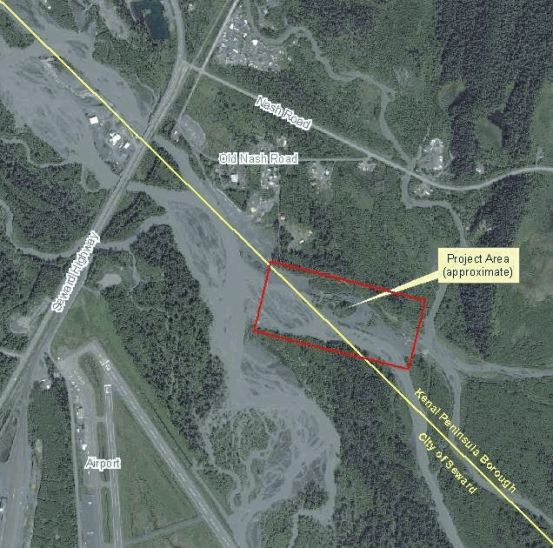
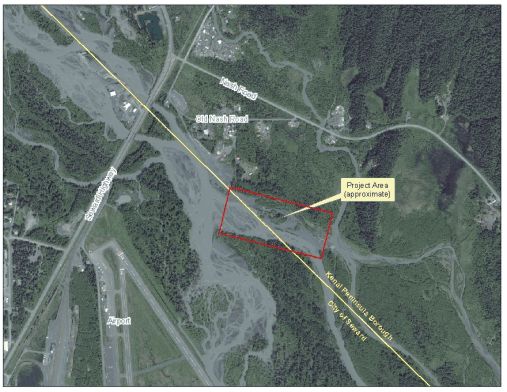
This plan is specific to a debris removal program for the original project area of the Resurrection River between the bridges at the Seward Highway and the outflow of the river, as required under DR-1072-AK, and as depicted on the attached map of the original project area.
KPB MAINTENANCE PLAN COMPONENTS
General steps that are components of this ongoing Maintenance Plan include:
An annual review of the original project area will be conducted in April to determine the need for periodic bed-load removal. Reviews will be logged for documentation.
This will remain a coordinated effort between KPB and the City of Seward. Both will keep SBCFSA informed.
Use of the area floodplain map is an intrinsic part of this plan. The KPB will work cooperatively
with the State of Alaska (DCCED) and the Federal Emergency Management Agency (FEMA) to
seek funding to update the floodplain map of the area.
![]()
The SBCFSA, City, and the Kenai River Center (KRC) will be involved in this process to make planning and mitigation most effective.
Agencies with a vested interest in the floodplain will cooperate and combine efforts where possible
to provide the mapping component (USGS, State of Alaska, DNR, Army Corps of Engineers,
Chugach National Forest, NRCS, etc.).
![]()
If funding is not expected to be immediately available, agencies will assist as much as possible until funding is available.
KPB will search for and secure funds, and issue permits for an annual maintenance schedule and contracts to remove debris as needed.
KPB will coordinate debris removal funding with the annual evaluation of the need for periodic bed-load removal.
KPB will coordinate applications for grants and technical partnerships to complete comprehensive
hydrologic studies to evaluate channel morphology, stability, and bed-load transport.
![]()
To include Corps of Engineers, FEMA, NRCS, DOT/PF, ARR, KPB, SBCFSA, Chugach National Forest, ADF&G and USF&W.
All agencies will work cooperatively to ensure flood mitigation/maintenance efforts are not being duplicated and permit issues are cooperatively addressed in a timely manner.
KPB has requested DNR to abate the sales contract and fee/royalty component of extraction
permits as they relate to government sponsored mitigation/maintenance efforts.
![]()
When requested by the City, KPB will work to facilitate:
Regulatory permitting required for changes to the project area watercourse, including City Floodplain Development permits.
Other actions the City and KPB deem necessary.
FLOODPLAIN MAPPING
All major waterways in the area, including the project area, need a hydrology study to determine
the most appropriate methods of debris removal including bed-load extraction, floodplain
conservation, and maintenance. Updated floodplain maps are essential to provide the most
accurate data for permitting and regulatory enforcement.
![]()
DAMAGE/DEBRIS CAUSES & ONGOING MAINTENANCE
Resurrection River is highly impacted by retreating glaciers, which are providing more melt and escalated stream flow, causing an amplified amount of glacial silt, gravel, and other debris being transported.
1. Bed-load build-up.
a. KPB and City of Seward as applicable, will annually monitor and evaluate the necessity of bed-load removal within the original project area in cooperation with DOT/PF and other affected agencies.
b. KPB and City of Seward will continue to perform debris removal maintenance within the original project area as necessary for their respective jurisdictions.
2. During times of high water, Resurrection River has caused significant flood damage to the Airport.
a. Preventative maintenance and restoration of the Airport are the responsibility of
DOT/PF.
![]()
b. KPB will coordinate with DOT, DNR, City of Seward and appropriate permitting
agencies to create a direct channel in the original project area by bed-load
removal from the mainstream channel to maintain water conveyance away from
the Airport.
3. KPB will coordinate with appropriate agencies to obtain funding and permitting to establish
an annual maintenance schedule and contracts to remove debris within the original project
area.
a. Jurisdictions to share and coordinate such plans include DOT/PF, ARR, KPB, City of Seward, SBCFSA, Chugach National Forest, National Park Service, ADF&G, USF&W, & Corps of Engineers.
ACTIONS ALREADY TAKEN
The SBCFSA and City of Seward Planning and Zoning Commission include agenda slots for mutual presentation related to flood mitigation planning and permitting.
LAND USE MANAGEMENT FLOODPLAIN AREAS
1. The KPB participates in the National Flood Insurance Program (NFIP) and the Community Rating System (CRS) Program;
2. Completed development of a Borough-wide All Hazard Mitigation Plan, including a section
specifically for Flood Hazard Mitigation;
![]()
3. City of Seward has completed and adopted an All-Hazard Mitigation Plan, including a section specifically for Flood Hazard Mitigation;
4. Continuing flood education and outreach through workshops and community meetings;
5. Providing a local source of information on proper floodplain building techniques; and
6. Review and revision of the KPB Floodplain Management Ordinance to improve the clarity, implementation, and enforceability of the floodplain code to include amending platting regulations to exclude streambeds from vegetated bank to vegetated bank from parcels.
OBJECTIVE 1.0:
ACTION 1.1: Develop Inventory of Problem Areas.
Assemble a detailed inventory of problem areas, flood structures, and infrastructure within and adjacent to the project area.
LEAD: SBCFSA/KPB OEM, City of Seward
SUPPORT: KPB Public Works, KPB Road Service Area (RSA), DHS&EM, DOT&PF, and DNR
TIMELINE: 1 – 3 years to coincide with floodplain mapping
PRIORITY: Medium
OBJECTIVE 2.0:
ACTION 2.1: Develop Inventory of Potential Retrofit/Rehab Measures
Assemble a detailed inventory of potential measures and activities for long-term maintenance to include channel diversion, etc.
LEAD: SBCFSA/KPB OEM, City of Seward
SUPPORT: KPB Public Works, KPB Road Service Area (RSA), DHS&EM, DOT&PF, DNR, AKRR, Army Corps of Engineers, ADF&G, USGS, USF&W
TIMELINE: 3 – 5 years
PRIORITY: Medium
OBJECTIVE 3.0:
Seek grants/technical partnerships to complete map and hydrology studies and compile information.
ACTION 3.1: Determine Funding Needs
ACTION 3.2: Scope of Work
ACTION 3.3: Identify Involved Agencies Having Funds and Services
An overall scope of work would help determine funding needs. Identifying agencies with vested interests would identify funding and in-kind services (hydrologists, mapping information and systems, historical data, etc). A database could then be developed to identify project priorities fore infrastructure protection, community growth, development restriction needs, etc.
LEAD: SBCFSA/KPB OEM, City of Seward
SUPPORT: KPB Public Works, KPB Road Service Area (RSA), DHS&EM, DOT&PF, DNR, KPB OEM, Chugach National Forest, USGS, Army Corps of Engineers
TIMELINE: 1 – 3 years
PRIORITY: High
OBJECTIVE 4.0:
Use information gathered in the comprehensive studies to enhance maintenance strategies.
ACTION 4.1: Consolidate Information
ACTION 4.2: Distribute to Involved Agencies for Planning and Funding
Such information is scattered, archived and difficult to retrieve. A catalog of information with regular revisions will keep responsibilities and issues in the forefront for planning and budgeting.
LEAD: SBCFSA/KPB OEM, KRC
SUPPORT: KPB Public Works, KPB Road Service Area (RSA), DHS&EM, DOT&PF, DNR, KPB OEM, Chugach National Forest, USGS, Army Corps of Engineers, City of Seward
TIMELINE: 1 – 3 years
PRIORITY: Medium
OBJECTIVE 5.0:
Periodic Review and Update of Information.
ACTION 5.1: Conduct Annual Review of Plan
ACTION 5.2: Incorporate Information from Additional Studies
ACTION 5.3: Incorporate Information from Additional Mapping.
All agencies have an interest in current information. Annual review and revision is essential to validation of the Plan.
LEAD: SBCFSA/KPB OEM, City of Seward
SUPPORT: All agencies involved in the Task Force as noted under History, 1997, in this document
TIMELINE: Annually
PRIORITY: High
OBJECTIVE 6.0:
Update Hazard Mapping (Digital Elevation Mapping).
ACTION 6.1 Seek Funding to complete (DEM) for all KPB floodplains and
coastal bluffs - Seward area is the priority.
Acquiring digital elevation data is a valuable first step to understanding surface water hydrology, hazard assessment, and emergency response planning and actions. Verify existing, and install additional, vertical elevation benchmarks in developing floodplains to facilitate accurate base flood elevation. Map actual flood boundaries after major flood events.
LEAD: KRC, KPB, City of Seward
SUPPORT: SBCFSA, all agencies involved in the Task Force with permitting authority as noted in History, 1997, in this document
TIMELINE: 1 – 2 years with annual revisions
PRIORITY: High
OBJECTIVE 7.0:
Prioritize and implement cost effective strategies for controlling flood damage.
ACTION 7.1 Seek Grants and Partnerships to Complete Comprehensive
Hydrologic Studies
ACTION 7.2 Identify Repetitive Flood Problems; Evaluate Channel Morphology And Stability, Bed Load Transport And Location And Effectiveness Of Existing Flood Control Structures.
Priorities for funding and planning can be established with this information for infrastructure, habitat and wildlife protection.
LEAD: KRC, KPB, City of Seward
SUPPORT: SBCFSA, all agencies involved in the Task Force with permitting authority
TIMELINE: 1 – 2 years with annual revisions
PRIORITY: High
OBJECTIVE 8.0:
ACTION 8.1 Recommend KPB Administration Institute a Revolving Flood Maintenance Fund
Fund could assist with Borough maintained road and capital projects, with those in the Resurrection drainage as the priority. With Seward and the State following suit, a consistent funding mechanism could be put in place.
LEAD: KPB OEM outside City limits
City of Seward inside City limits
DOT/PF for State highway, ROW & Airport
SUPPORT: All agencies involved in the Task Force with permitting authority as noted in History 1997 in this document
TIMELINE: 1 – 3 years
PRIORITY: High
OBJECTIVE 9.0:
Coordinate scheduling of projects during low water
ACTION 9.1 Use Sediment Control Techniques To Stabilize Fill Or Disturbed Areas
ACTION 9.2: Schedule In-Water Work To Periods Least Likely To Impact Salmon Migration, Spawning, Incubation and Rearing.
LEAD: KPB OEM outside City limits
City of Seward inside City limits
DOT/PF for State highway, ROW & Airport
SUPPORT: Chugach National Forest, USF&W, ADF&G, Army Corps of Engineers, KPB RSA, AKRR, property owners/developers
TIMELINE: 1 – 3 years
PRIORITY: High
OBJECTIVE 10.0:
Maintain Water Level At or Below Original Project Levels.
ACTION 10.1 Conduct Ongoing Maintenance such as Emergency Debris Removal or Stream Re-Channelization.
Carefully evaluate for long-term consequences including: increased maintenance costs, shifting problem from one place to another, and adverse hydrological or environmental impacts.
LEAD: KPB OEM outside City limits
City of Seward inside City limits
DOT/PF for State highway, ROW & Airport
SUPPORT: Chugach National Forest, USF&W, AKF&G, Army Corps of Engineers, KPB RSA, AKRR
TIMELINE: 1 – 3 years
PRIORITY: High
ADFG - |
Alaska Dept. of Fish and Game |
ARR - |
Alaska Railroad |
CITY - |
City of Seward |
CRS - |
Community Rating System |
DCA - |
Alaska Division of Community Advocacy |
DCCED - |
Alaska Dept. Commerce, Community and Economic Development |
DEM - |
Digital Elevation Mapping |
DHS&EM |
Division of Homeland Security and Emergency Management (Formerly ADES - Alaska Division of Emergency Services) |
DNR - |
Department Of Natural Resources |
DOT/PF - |
Alaska Dept. of Transportation and Public Facilities |
FEMA - |
Federal Emergency Management Agency |
FMA - |
Flood Mitigation Assistance |
GIS - |
Geographic Information Services |
KPB - |
Kenai Peninsula Borough |
KRC - |
Kenai River Center |
MACG |
Multi-agency Coordination Group |
NFIP - |
National Flood Insurance Program |
NRCS - |
National Resources Conservation Service |
OEM - |
Office of Emergency Management |
RSA - |
Road Service Area |
SBCFSA - |
Seward-Bear Creek Flood Service Area |
SOA - |
State Of Alaska |
USFW - |
United States Fish and Wildlife |
USGS - |
United States Geological Survey |
ATTACHMENTS
1. KPB & City of Seward Resolutions of adoption of the Plan
2. Reference Material
3. SBCFSA Flood Mitigation Plan (www.sewardbearcreekfloodsericearea.org)
4. All Hazard Mitigation Plans (www.borough.kenai.ak.us/emergency)
5. North Forest Acres Levee document (www.cityofseward.com) - Planning Department
6. KPB Ordinance 98-55 (financial commitment as required under Plan)
7. City of Seward Ordinance 98-10 (financial commitment as required under Plan)
8. Agency letters of endorsement of Plan
9. Seward Airport Master Plan
SIGNATURE PAGE
KPB Mayor
KPB Assembly President
City of Seward Mayor
City of Seward City Manager
SBCFSA Board President